Southeast Asia, explained.
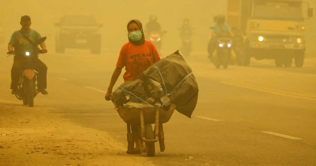
Thick haze from forest and land fires in the region in Palangkaraya, Central Kalimantan, on 25 October 2026 (Reina/AFP via Getty Images)
Satellite and AI capability is outpacing the institutions built to act on it.
Subscribe to The Informer for monthly expert analysis, and to Events for advance notice of visiting world leaders and distinguished guests.
You may unsubscribe from Lowy Institute newsletters at any time. For information on our privacy practices and how to unsubscribe, see our Privacy Policy.
ASEAN haze: the tech is ready, the enforcement isn’t
On 26 August 2026, the ASEAN Specialised Meteorological Centre (ASMC) activated Alert Level 3 (Opens in new window), its highest haze alert, for southern ASEAN. Four days later, satellite imagery recorded (Opens in new window) 1,211 hotspots across the region, including 1,180 in Kalimantan.
Southeast Asia has struggled with transboundary haze for decades. The ASEAN Agreement on Transboundary Haze Pollution (Opens in new window) entered into force in 2003, and Indonesia’s ratification (Opens in new window) in 2014 brought all ASEAN member states at the time on board. Singapore also introduced its Transboundary Haze Pollution Act (Opens in new window) in 2014. Yet haze continues to return to the region, at serious health, environmental, and economic cost.
What has changed is the technology. Earth observation satellites provide detailed information about fires and land conditions, while artificial intelligence (AI) can help identify patterns and forecast risks. But technology has rarely been the only missing piece. Each capability is useful only when paired with a governance arrangement that turns information into action.
Satellites remain central to haze monitoring. Thermal instruments detect active fires several times a day, optical imagery maps burned areas, and radar sees through cloud and smoke. Yet detection helps only if someone is mandated to respond. Hotspot data must feed into agreed protocols specifying which agency verifies a fire, within what timeframe, and who deploys suppression teams.
Technology alone cannot make up for weak implementation, or the failure to hold those responsible for fires to account.
AI can go further by identifying where fires are likely to occur. A study (Opens in new window) used remote-sensing data and machine learning to predict forest fires in Indonesia. Combining water-table sensors, rainfall forecasts, satellite soil-moisture estimates, and radar observations could also flag degraded and drained peatlands (Opens in new window) becoming dangerously dry before hotspots appear. Such forecasts still need operational validation, and matter only if warnings compel action. Authorities need the legal mandate and resources to inspect flagged areas, require concession holders to rewet peat, and sanction those who do not.
A hotspot map cannot explain which communities face the greatest risks, where smoke will travel, or which interventions should come first. Projects such as MIT Media Lab’s Earth Mission Control (Opens in new window) and NASA’s VIIRS (Opens in new window) show how satellite data can be presented through interactive maps. Southeast Asian states could combine fire-risk forecasts, wind direction, and satellite imagery with the locations of communities, hospitals, and schools.
A shared picture, however, needs shared rules. States need to agree on alert thresholds that trigger specific responses, and on who issues public advisories when smoke crosses borders. These rules must be built around practical questions, such as which communities face smoke exposure and where prevention should come first, with local knowledge and human judgement kept central.
The haze in Southeast Asia has been a problem over years (Sergei Gussev/Flickr)
That said, AI models trained on historical data may struggle with extreme events beyond their training experience. AI-powered social media monitoring can overlook communities using local languages or lacking reliable internet access. And plausible but inaccurate outputs are dangerous when warnings must be fast. The governance response is to document model limitations and require designated officials to review AI-informed warnings before release.
Institutional fragmentation is harder to fix. Indonesian peat fire management has been spread across (Opens in new window) national, provincial, and village institutions, with no single body in charge. When the peat restoration agency’s mandate ended in 2024, its sensor network and expertise were handed to (Opens in new window) ministries and local authorities, and it is unclear how much of its coordination survives. A planned successor (Opens in new window) has yet to be established, while access to forest and fire data has been restricted (Opens in new window).
As experts argue (Opens in new window), what ASEAN lacks is not law but the machinery to enforce its haze agreement. The Second ASEAN Haze-Free Roadmap (2023–30) (Opens in new window) already calls for stronger early warning, fire detection, and information sharing, while the ASEAN Guide on AI Governance and Ethics (Opens in new window) emphasises transparency, reliability, and accountability. Applying these principles to haze monitoring could connect two agendas that have largely progressed separately.
First, pair open satellite data with clear institutional roles. Open data from Sentinel-1 (Opens in new window), Sentinel-2 (Opens in new window), Landsat (Opens in new window), and NISAR (Opens in new window) can support fire-risk forecasting and land monitoring at low cost. The ASEAN Coordinating Centre for Transboundary Haze Pollution Control (Opens in new window) could, potentially and eventually, host a shared dashboard overlaying hotspots on concession maps. But right now, its operational capacity remains uncertain. Responsibility for acting on warnings must stay with national authorities.
Second, pool data and test. Indonesia can draw on the combined capacity of its neighbours, including ASMC in Singapore and other national space agencies in the region. Southeast Asian countries could then pool hotspot and burned-area datasets, peatland information, and advisory templates in regional languages, and test models against severe fire seasons.
Third, close the capacity gap. Better resourced ASEAN member states can offer training, satellite ground-station access, computing resources, and technical assistance through a regional shared-service model, while national agencies retain control over local data and operational decisions.
ASEAN’s goal of a haze-free region by 2030 requires more than technological infrastructure or advancement. Technology is unevenly distributed across the region, and many of the hardest problems are physical (Opens in new window): blocking drainage canals, rewetting peat, and reaching fires in remote terrain.
Space and AI can show where action is needed, but only enforcement, accountability, and cross-border cooperation can ensure change happens. Technology alone cannot make up for weak implementation, or the failure to hold those responsible for fires to account.
About the authors
Karryl Kim Sagun Trajano
Karryl Kim Sagun Trajano is a Research Fellow for Future Issues and Technology (FIT) at the S. Rajaratnam School of International Studies (RSIS), Nanyang Technological University (NTU), Singapore.
Iuna Tsyrulneva
Iuna Tsyrulneva is a Research Fellow at the Earth Observatory of Singapore (EOS), Nanyang Technological University (NTU), Singapore.
Topics
Key Finding by Rahul Nath, Taili Ni + 3 others
Key Finding by Rahul Nath, Taili Ni + 3 others
Key Finding by Rahul Nath, Taili Ni + 3 others
Overview by Rahul Nath, Taili Ni + 3 others
The most-pressing world events explained by Lowy Institute experts and global contributors, in your inbox, every Thursday.
You may unsubscribe from The Interpreter at any time. For information on our privacy practices and how to unsubscribe, see our Privacy Policy.
The Lowy Institute is an independent Australian think tank producing authoritative research, innovative data tools, and expert commentary on international affairs. We acknowledge the Gadigal people of the Eora nation, the traditional custodians of the land on which the Institute stands, and pays respects to their Elders, past and present.
Copyright © 2026 Lowy Institute, 31 Bligh Street, Sydney NSW 2000, Australia
About the Author